Showing posts with label Tetlin National Wildlife Refuge. Show all posts

Sunday, June 30, 2013

Heavy Rain Slows Chisana River Fire


June 29, 2013
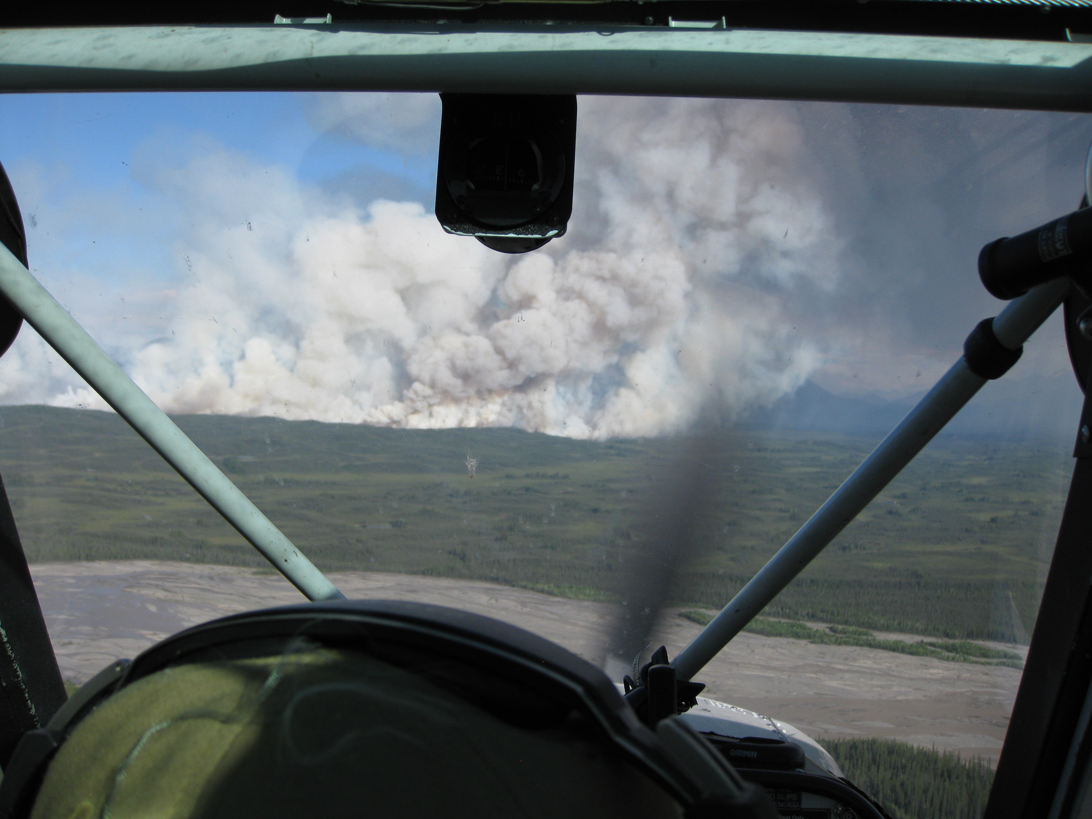
Beaver Creek, Yukon –– Heavy rain has dampened growth and activity on the Chisana River Fire in Alaska’s Eastern Interior. As a result, the international team managing the fire from Beaver Creek, Yukon, Canada is disbanding after a productive, cooperative effort. The Alaska Division of Forestry will continue to monitor the fire.

The fire was started by lightning May 31and is burning in Wrangell-St. Elias National Park and in the Tetlin National Wildlife Refuge. It is estimated at approximately 45,950 acres. The slight decrease in acreage from the previous estimate is due to better mapping of the fire.

No resources are threatened by the fire, but fire managers have developed contingency plans and are prepared to take action if that changes. The fire is approximately 13 miles west of the Canadian border, 17.5 miles west of Beaver Creek, Yukon, Canada and 21 miles northeast of Chisana.

Thursday, June 20, 2013

Chisana River Fire Grows, Impacts the Copper River Valley

Smoke from the Chisana River Fire impacted the Copper River basin on the evening of July 18. Because the fire continues to grow anticipate varying levels of
smoke impacting the area.

The Chisana River fire grew from 7,718 acres on June 17 to 25,566 acres on June 18. The fire continued its growth to the south and west with some growth east - isolated tree torching and short range spotting was observed. Interagency fire staff provided protection to a structure that is southwest of the fire. The fire will continue to be monitored with planned flights today around 5:00pm.

The fire is located 82 miles east of Slana, 21 miles northeast of Chisana, 19 miles west of Beaver Creek, Canada and approximately 14 miles southwest of the Alaska Highway border crossing. The State of Alaska Division of Forestry is monitoring the fire closely to document fire behavior and growth, while consulting with the fire management officers from the U.S. Fish and Wildlife Service, National Park Service, and Yukon Territory in Canada.

Smoke will be visible and even heavy at times, in both Alaska and Canada. In Alaska, smoke will be likely visible throughout the Copper River Basin, from the Alaska-Canada border crossing, and along portions of the Alaska Highway. Wildland fire smoke information is available at http://www.dec.state.ak.us/air/smokemain.htm. If smoke becomes an impact to the highway, motorists are asked to use caution by slowing down and driving with their headlights on.

The fire is in a Limited suppression management option, per the Alaska Interagency Wildland Fire Management Plan. Wildfire is a natural process in the boreal forest. The fire is burning on U.S. Fish and Wildlife and National Park Service lands and agency personnel are allowing the wildfire to take its natural course.It is nature's way of renewing and revitalizing the landscape. Naturally-caused wildfires have on occasion burned in the northeastern portion of Wrangell-St. Elias and Tetlin National Wildlife Refuge. Interagency fire managers will take action if structures, natural or cultural resources are threatened. None are threatened at this time. Visit http://www.nps.gov/wrst/parkmgmt/loader.cfm?csModule=security/getfile&pageID=385664 to see a map of the area's wildfire history.

Several fires are burning statewide. For interagency wildland fire information, visit http://fire.ak.blm.gov or call 907-356-5511. Information about fires burning on National Park Service lands throughout Alaska is provided athttp://www.nps.gov/wrst/parkmgmt/currentfireinfo.htm. For additional information, please contact Mark Keogh at 907-822-7223.

Wednesday, June 19, 2013

Amazing Images of Alaska Wildfire

Due to continued hot and dry conditions, the Chisana River Fire grew from 2,900 acres to 7,718 acres June 17. The wildfire moved south from Tetlin Wildlife Refuge into northeastern Wrangell-St. Elias NP. As of June 17, the wildfire had
burned 3,847 acres in Tetlin Wildlife Refuge and 3,871 acres in Wrangell-St. Elias NP. The increased fire activity resulted in a 10,000 foot column of smoke that was visible from the Alaska Highway in Yukon Territory, Gulkana and McCarthy. Smoke from the fire can likely be seen and smelled in the Copper River Basin. Today, forecast extreme fire conditions will likely contribute to continued large fire growth and a large and visible column of smoke.

The Chisana River Fire is located 82 miles east of Slana, 37 miles northeast of Chisana, 19 miles southwest of Beaver Creek, Canada and approximately 14 miles southwest of the Alaska Highway border crossing. The U.S. Fish and Wildlife Service, Wrangell-St. Elias NP and State of Alaska Division of Forestry fire staff will continue to monitor the fire closely, documenting fire behavior and growth. Interagency fire managers will take action if structures, natural or cultural resources are threatened. None are threatened at this time. Fire managers are also communicating with Yukon Territory officials on a daily basis.

Staff are allowing the wildfire to take its natural course. Wildfire is a natural process in the boreal forest. It is nature's way of renewing and revitalizing the landscape. Naturally-caused wildfires have on occasion burned in the northeastern portion of Wrangell-St. Elias and Tetlin National Wildlife Refuge. Visit http://www.nps.gov/wrst/parkmgmt/loader.cfm?csModule=security/getfile&pageID=385664 to see a map of the area's wildfire history.

Visit http://www.nps.gov/wrst/parkmgmt/currentfireinfo.htm for current fire information.

Saturday, June 15, 2013

Four lightning caused wildfires in northeastern Wrangell St Elias NP, two active, one quiet, one out

Copper Center, Alaska – A new wildfire was spotted by State of Alaska Division of Forestry (DOF) fire staff June 11 in northeastern Wrangell-St. Elias NP. The Bruin Creek fire is 73 miles southeast of Slana, 22 miles northeast of Chisana, 28
miles west of Beaver Creek, Canada and 16 miles southwest of the Chisana River Fire. At 2 acres, the fire was inactive except for a few smokes. Wrangell-St. Elias NP and DOF fire staff will monitor the fire closely.

Two park cabins are nearly 3 miles southeast of the Bruin Creek Fire. Today six interagency fire staff will remove brush around the cabins to make them defensible should the fire activity increase and advance toward the structures. Staff will also set up sprinkler kits in order to wet down the structures and reduce the fire risk. Temperatures in the area are expected to stay warm and dry.

The Chisana River Fire located 82 miles east of Slana, 37 miles northeast of Chisana and 19 miles northwest of Beaver Creek, Canada is 3175 acres. The majority of the fire burns in the Tetlin National Wildlife Refuge. Twenty-nine acres are in northeastern Wrangell-St. Elias National Park. The U.S. Fish and Wildlife Service, Wrangell-St. Elias NP and DOF fire staff will continue to monitor the fire, documenting fire behavior and growth. Staff are allowing the fire to take its natural course for the health of the boreal forest. Interagency fire managers will take action if structures, natural or cultural resources are threatened.

A quiet Edge Creek Fire was reported June 12. Less than ¼ acre, the fire is located just north of the Bruin Creek Fire and will be monitored by Wrangell-St. Elias and DOF fire staff.

When detected June 5, the 1 acre Tractor Trail Fire was out. Located south of the Bruin Creek Fire, it likely was ignited by lightning, burned for a short period of time and then rain extinguished it.

Naturally-caused wildfires have on occasion burned in the northeastern portion of Wrangell-St. Elias. Visit http://www.nps.gov/wrst/parkmgmt/loader.cfm?csModule=security/getfile&pageID=385664 to see a map of the park's wildfire history.

Visit http://www.nps.gov/wrst/parkmgmt/currentfireinfo.htm for current fire information.

For additional information please contact Mark Keogh at 907-822-7223.

Thursday, January 5, 2012

Fortymile Caribou Hunt Closed in a Portion of Game Management Unit 20E

Boundary Map of Tetlin National Wildlife Refuge
Image via Wikipedia

Correction: An earlier version of this news release incorrectly listed the state Fortymile caribou hunt in Unit 25C as closed south of Crooked Creek Fork and south and east of Birch Creek.

FAIRBANKS, Alaska —A portion of the winter federal subsistence hunt for the Fortymile Caribou Herd in Game Management Unit 20E closed on Monday, Dec. 26, 2011, at 11:59 p.m. The closure affects that portion of Unit 20E south of an east–west line passing through Milepost 112.6 (Fortymile Bridge) on the Taylor Highway.

The Bureau of Land Management’s Eastern Interior Field Office Manager Lenore Heppler took this action because of the lack of Fortymile caribou in the area as well as the ready access to Nelchina and Mentasta caribou (the Taylor Highway has remained driveable). The Nelchina quota has already been exceeded, and there is no open season on Mentasta caribou. Consultation on the closure was conducted with the Alaska Department of Fish and Game in Tok and Glennallen, Tetlin National Wildlife Refuge, National Park Service and local subsistence hunters.

The state and federal winter season for Fortymile caribou remains open in Unit 20E north of MP 112.6 on the Taylor Highway. No changes have been made to the Fortymile caribou season in other parts of the hunt area. In Unit 25C all federal lands remain open for federally qualified residents to hunt the Fortymile herd. The state portion of the Fortymile caribou hunt remains open in Unit 25C south of Crooked Creek Fork and south and east of Birch Creek,and south of the Chatanika River drainage in Unit 20B.

For additional information, contact Eastern Interior Field Manager Lenore Heppler at 907-474-2320 or lheppler@blm.gov. The Fortymile Caribou Hotline phone number is (907) 267-2310.