Showing posts with label Copper Center Alaska. Show all posts

Friday, June 21, 2013

Chisana River Fire Growth Slows

Copper Center, Alaska –– The Chisana River Fire activity slowed on June 19 moving in a southerly direction on the east side of the River with isolated and group torching.The fire grew from 25,566 to 29,287 acres. Wednesday's actions
included precautionary site protection for two cabins-- sprinklers and removal of flammable vegetation -- and the fire was mapped to determine the perimeter.

The fire is located 82 miles east of Slana, 21 miles northeast of Chisana, 19 miles west of Beaver Creek, Canada and approximately 14 miles southwest of the Alaska Highway border crossing. The State of Alaska Division of Forestry is monitoring the fire closely to document fire behavior and growth, while consulting with the fire management officers from the U.S. Fish and Wildlife Service, National Park Service, and Yukon Territory in Canada. Fire managers will take action if structures or natural or cultural resources are threatened. None are threatened at this time. The fire will be flown again at 5:00 p.m. today.

Information will be updated when significant changes in fire activity occur. Information and photos are also available at http://inciweb.org/incident/3440/.

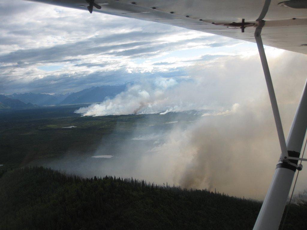
Smoke will be visible and even heavy at times, in both Alaska and Canada. In Alaska, smoke will be likely visible throughout the Copper River Basin, from the Alaska-Canada border crossing, and along portions of the Alaska Highway. Wildland fire smoke information is available at http://www.dec.state.ak.us/air/smokemain.htm. If smoke becomes an impact to the highway, motorists are asked to use caution by slowing down and driving with their headlights on.

Several fires are burning statewide. For interagency wildland fire information, visit http://fire.ak.blm.gov or call 907-356-5511. Information about fires burning on National Park Service lands throughout Alaska is provided at http://www.nps.gov/wrst/parkmgmt/currentfireinfo.htm. For additional information, please contact Mark Keogh at 907-822-7223.

Saturday, June 15, 2013

Four lightning caused wildfires in northeastern Wrangell St Elias NP, two active, one quiet, one out

Copper Center, Alaska – A new wildfire was spotted by State of Alaska Division of Forestry (DOF) fire staff June 11 in northeastern Wrangell-St. Elias NP. The Bruin Creek fire is 73 miles southeast of Slana, 22 miles northeast of Chisana, 28
miles west of Beaver Creek, Canada and 16 miles southwest of the Chisana River Fire. At 2 acres, the fire was inactive except for a few smokes. Wrangell-St. Elias NP and DOF fire staff will monitor the fire closely.

Two park cabins are nearly 3 miles southeast of the Bruin Creek Fire. Today six interagency fire staff will remove brush around the cabins to make them defensible should the fire activity increase and advance toward the structures. Staff will also set up sprinkler kits in order to wet down the structures and reduce the fire risk. Temperatures in the area are expected to stay warm and dry.

The Chisana River Fire located 82 miles east of Slana, 37 miles northeast of Chisana and 19 miles northwest of Beaver Creek, Canada is 3175 acres. The majority of the fire burns in the Tetlin National Wildlife Refuge. Twenty-nine acres are in northeastern Wrangell-St. Elias National Park. The U.S. Fish and Wildlife Service, Wrangell-St. Elias NP and DOF fire staff will continue to monitor the fire, documenting fire behavior and growth. Staff are allowing the fire to take its natural course for the health of the boreal forest. Interagency fire managers will take action if structures, natural or cultural resources are threatened.

A quiet Edge Creek Fire was reported June 12. Less than ¼ acre, the fire is located just north of the Bruin Creek Fire and will be monitored by Wrangell-St. Elias and DOF fire staff.

When detected June 5, the 1 acre Tractor Trail Fire was out. Located south of the Bruin Creek Fire, it likely was ignited by lightning, burned for a short period of time and then rain extinguished it.

Naturally-caused wildfires have on occasion burned in the northeastern portion of Wrangell-St. Elias. Visit http://www.nps.gov/wrst/parkmgmt/loader.cfm?csModule=security/getfile&pageID=385664 to see a map of the park's wildfire history.

Visit http://www.nps.gov/wrst/parkmgmt/currentfireinfo.htm for current fire information.

For additional information please contact Mark Keogh at 907-822-7223.

Monday, August 13, 2012

Federal subsistence hunting permits for Wrangell St Elias National Park and Preserve available

Welcome sign at the entrance to Wrangell–St. E...
(Photo credit: Wikipedia)
Federal subsistence registration permits for permit hunts in Wrangell-St. Elias National Park and Preserve are available at the park's Visitor Center in Copper Center, the Slana Ranger Station, and the Chitina Ranger Station.Please bring your State of Alaska resident hunting license, a photo ID (such as a driver's license), and proof of your local physical address (such as a voter registration card or utility bill listing the physical address) when you come to get a permit. Regular season sheep hunters, make sure you get a state harvest ticket and seal the horns. For more information, call 822-5234.

Thursday, April 19, 2012

Wrangell St Elias To Hold Public Hearing Regarding Closure of Malaspina Forelands To Use Of Off-Road Vehicles For Subsistence

Ponds of water on a glacier, Wrangell-St. Elia...
(Photo credit: Wikipedia)
Copper Center, AK - The Wrangell-St. Elias National Park and Preserve is proposing to close the Malaspina Forelands and other lands in its Yakutat District to the use of off-road vehicles (ORVs) for subsistence access. The closure is needed to prevent damage to park resources. It would apply to all portions of the Park and Preserve south of the Bagley Ice Field and Seward Glacier, extending east to the western margin of the Hubbard Glacier. A public hearing on the proposed closure will be held at the National Park Service's Yakutat Visitor Center on Tuesday, April 17, 2012, from 4 PM to 6 PM.

Local users including the Wrangell-St. Elias Subsistence Resource Commission have recommended that the Park Superintendent implement this closure to prevent damage to park resources on the Malaspina Forelands. The use of ORVs on the nearby Yakutat Forelands, even in the presence of regular monitoring and enforcement, has led to extensive resource damage in a relatively short period of time. Current NPS staffing in Yakutat does not allow for monitoring at the frequency needed to successfully address and prevent resource damage. This closure would be in effect until a determination by the Superintendent concludes that ORV use in this area no longer represents an unacceptable adverse impact on the resource.

Less restrictive measures will not be effective are because the park does not currently have the capacity to effectively monitor use or enforce permit conditions.A complete closure is the only option that can be adequately enforced at this time.

This closure would be a seasonal closure in effect only during summer months. During winter periods in which there is 6-12 inches of snow or more, or a combination of snow and frost depth sufficient to protect underlying vegetation and soil, these areas will be open to over snow vehicles. Use of ORVs will still be authorized for commercial fishermen under the authority of 36 CFR 13.40(c), and/or by permit issued by the Superintendent.

A map of the closed area is available for public inspection at the park headquarters in Copper Center, at the NPS Yakutat Visitor Center, at the Yakutat Post Office, and on the park web site at http://www.nps.gov/wrst/parkmgmt/subsistence-maps.htm.

Additional information may be obtained by calling Rick Obernesser, Superintendent, 907-822-5234.