Friday, July 12, 2013

Alaska Department of Fish and Game Questions Climate Cahnge and Endangered Species Act

In a brief press release dated July 9, 2013, ADF&G director Doug Vincent-Lang
Courtesy Alaska Dispatch
made two disturbing comments for the state official charged with overseeing endangered species.  It is further evidence that Alaska's state government has gotten out of whack with regard to the balance between needs of the environment and the profit motives of industry.

In an apparent misunderstanding of the words endangered and/or threatened, Mr. Vincent-Lang begins by stating, "This decision begins to bring rationality to the recent misapplication of the ESA that has resulted in the precautionary listing of currently abundant and robust species." Mr. Vincent-Lang is unaware or chooses to ignore the goal of conservation being to prevent the scenario where species will be endangered.  Undoubtedly, Mr. Vincent-Lang, as his career trajectory has demonstrated previously, was simply parroting the sentiment of superiors eager to make certain no impediments were thrust before the oil industry, mining concerns, or other commercial pursuits.

In the same sentence, and perhaps more disturbing in light of recent moves towards rationality by conservatives on climate change, Mr. Vincent-Lang went on to say additions to endangered species were "based on speculated and unproven climate-related impacts."  It is truly frightening to this author to hear an official of this magnificent state so unenthused for his charge as steward of the state's natural resources.

It would be more proper for him to resign and receive his paycheck from one of the industry groups he already represents.

Tuesday, July 9, 2013

Alaska Outdoor News and Events - July 9, 2013

Denali - Mountains - Alaska
Denali - Mountains - Alaska (Photo credit: blmiers2)

Denali National Park News

On July 20th, anthropologist Jane Bryant  will presnt a program on the 1932 Lindley-Liek Expedition of Denali.  This is part of the Centennial Series.  For additional information visit http://goo.gl/ScCp5.

BLM News

The North Slope Science Initiative seeks 6 new members for its advisory board.  Panel members can come from a range of scientific disciplines.  Nominations must be made by July 26th.  To find out how to nominate, go to http://www.northslope.org/.


Monday, July 8, 2013

BLM-Alaska Announces the Delta River Special Recreation Management Area Approved Plan

Delta River, Alaska

Glennallen, Alaska – The Bureau of Land Management in Alaska is pleased to release the Finding of No Significant Impact, Decision Record (DR) and Approved Plan for the Delta River Special Recreation Management Area (SRMA) and East Alaska Resource Management Plan Amendment (Approved Plan). This document will provide guidance for the recreational management of the Delta River SRMA for the next 15-20 years.
 
The Approved Plan is designed to provide for a mix of river recreation uses and users, while managing to protect the environment and Outstandingly Remarkable Values (ORV). It maintains a setting that supports diverse recreational opportunities; integrates resource protection with an appropriate range of visitor uses; contributes economically to local communities; provides multi-resource standards and direction found in other legislation, policies, or management plans designed to comply with applicable state and federal laws; and provides protection of the river’s scenic, cultural, wildlife, fisheries, and recreational ORVs.
 
The plan should minimize social conflicts and protect river resources through management direction that provides a strong emphasis in education and interpretive outreach. It calls for the establishment of adaptive management standards that are based on river user tolerances for different impacts. Monitoring and non-compliance with standards will drive implementation of management actions; in most cases, less-restrictive measures will be implemented prior to more-restrictive actions.
 
Bud Cribley, BLM-Alaska State Director commented, “I am especially pleased and grateful for all the participating stakeholders and general public who came together for this 7 year planning process. They opened up for consideration all the known issues, competing interests, opinions, and values of the public for inclusion in this plan.”
 
Copies of the Delta River SRMA Decision Record, Finding of No Significant Impact, and Approved Plan are available for viewing on the BLM Alaska Planning website at: http://www.blm.gov/ak/st/en/prog/planning.html. For members of the public that lack computer access, contact the BLM Glennallen Field Office by calling (907) 822-3217.
To view the Federal Register Notice, Click here:  https://www.federalregister.gov/articles/2013/07/01/2013-15681/notice-of-availability-of-the-decision-record-for-the-delta-river-special-recreation-management-area

Sunday, July 7, 2013

Smokejumpers Provide Structure Protection for Historic Denali Patrol Cabins

Toklat East River Fire, Denali NP, 2013, Photo...
Toklat East River Fire, Denali NP, 2013, Photo by Yasunori Matsui (Photo credit: AlaskaNPS)
DENALI PARK, Alaska: Eight smokejumpers were deployed late yesterday to provide structure protection to two historic ranger patrol cabins potentially threatened by the Wigand Creek and Toklat River East Fires, which will likely burn together today. The Lower Toklat cabin, built in 1931 and located approximately 23 miles north of the Denali Park Road, is approximately .8 mile west of the Toklat River East Fire. The East Fork cabin is about 4.5 miles east of the Toklat River East Fire. It was constructed in 1930 and is about 18 miles north of the road. The National Park Service fire crews removed shrubs, trees, and other potential fuel from the vicinity of the cabins within the past five years as part of the park's hazardous fuel treatment program. The smokejumpers are tentatively planning a burnout operation at the Lower Toklat Cabin as it is more at risk due to the fire's proximity. The jumpers at the Lower East Fork Cabin will do hose lays and prepare a sprinkler system.

Denali fire managers were able to fly over the park yesterday and map the fires that were not obscured by smoke. There has been minimal change in the size of most of the fires burning in the park.

The Beaver Log Lakes Fire is now 63,000 acres. Fire personnel will continue to mopup around the cabins and other structures where burnout operations took place on the north shore of Lake Minchumina.The Type 3 Incident Management Team (IMT) managing this fire and the 26,266- acre Moving River Fire will gradually downsize operations as fire conditions permit.

The more than 22,000–acre Sandless Lake Fire on the northern park boundary was mapped yesterday and observers saw active fire on most of its perimeter. Due to heavy smoke portions of the fire were estimated. Areas that burned in 2009 are to the north and west of the fire.

The McKinley River East Fire that is 14 miles northwest of Wonder Lake was mapped at 4,417 acres. Little fire activity was seen during yesterday's overflight. It is burning in an area adjacent the McKinley River where a large fire burned in 1986.It and other lightning-ignited fires burning in remote backcountry areas of the park are not threatening any critical park resources, and will continue to be monitored for any significant changes in activity.

Visit http://www.nps.gov/dena/parkmgmt/currentfireinfo .htm for current information about wildfires in Denali National Park and Preserve. This will be the last daily press release on Denali fires until fire activity changes significantly.

Fire danger for the park and surrounding area is moderate to high. The National Park Service is urging park visitors to be extremely cautious with anything that could start a wildfire. Campfires are discouraged, but they are permitted in the fire grates in three of the park's campgrounds.Fires are not allowed in the park's wilderness areas. Fireworks are not allowed in the park and will be confiscated. Persons using fireworks in the park may be prosecuted.

There are currently 109 active wildfires in the state. Where there is fire, there is smoke. Due to the current and expected statewide fire activity, park visitors should anticipate the possibility of varying levels of smoke in the park. Wildfire smoke information is available at http://dec.alaska.gov/air/smokemain.htm. Visithttp://fire.ak.blm.gov for statewide information and a map of the active fires.

Friday, July 5, 2013

Flightseers Remain Weathered-In on the Ruth Glacier


TALKEETNA, AK: Six stranded flightseeing tourists and their pilot are reportedly in good health in the Ruth Amphitheater of Denali National Park and Preserve as they await flyable conditions for a return
flight to Talkeetna. Deteriorating weather during a routine flightseeing trip on Tuesday evening, July 2 forced Talkeetna Air Taxi pilot John Nealon to make a temporary landing on the Ruth Glacier for the safety of his passengers.Into the night, snowfall and cloud cover continued to build, so the seven of them slept in the DeHavilland Beaver, which was supplied with basic emergency gear including sleeping bags, food, a stove, and a satellite phone.
First thing the next morning, Talkeetna Air Taxi owner Paul Roderick alerted Denali National Park rangers that the aircraft and its passengers, including three men and three women, remained stranded.Continued clouds and intermittent snowfall throughout the day on Wednesday, July 3 thwarted attempts by both a Talkeetna Air Taxi fixed wing plane and the NPS A-Star helicopter to reach the aircraft.
Bad weather persisted at the landing site on Thursday morning, July 4.In order to avoid an emergency situation, a ground team of four Denali National Park mountaineering rangers was flown via helicopter to the lower Ruth Gorge late Thursday morning.The team will travel up-glacier approximately 3.5 miles with food, tents, and warm clothing to re-supply the group in the event their stay is prolonged further. The NPS rangers will remain with the visitors until they can fly out.
According to Denali National Park South District Ranger John Leonard, "Fortunately for all involved, this is not an emergency situation thanks to the sound judgement of the pilot and the emergency preparedness of the air service.Instead of pushing through bad weather, Nealon made the difficult decision to land and face a night or two of discomfort.Gratefully, today we are conducting a re-supply mission instead of responding to an accident."

Wednesday, July 3, 2013

Chinook Winds Fan Toklat Basin Fires

DENALI PARK, Alaska: There was little change in the size of most of the fires burning in Denali National Park and Preserve over the past 24 hours, with the exception of two burning in the Toklat Basin north of the Denali Park Road. Yesterday afternoon chinook winds gusting from the Alaska Range pushed the Wigand and Toklat River East Fires north over one and seven miles respectively, which also significantly increased the size of both fires. The Wigand Fire is now an estimated 1,790 acres and the Toklat River East Fire is 8,928 acres. Fire managers were not able to obtain an accurate fire perimeter due to the smoke in the area. These fires may merge, as they are in close proximity to each other. The historical Lower Toklat and Lower East Fork ranger patrol cabins are potentially threatened by the increased fire activity. Four smoke jumpers were deployed at each cabin this afternoon after fire managers were able to fully assess the structural protection needs.

map of fires around Denali
Map of fires in Denali. Click the image above to view a larger version. Updated July 2, 2013
 
Nine wildfires are burning in the park.

The 59,000-acre Beaver Log Lakes Fire is the only other fire being staffed, and it is managed by the Type 3 Incident Management Team (IMT) based at Lake Minchumina.Fire personnel have successfully burned out areas around cabins and other buildings on the north shore of Lake Minchumina and are continuing to mop up around these structures.

The Moving River Fire approximately 30 miles northwest of Kantishna is now 26,266 acres and is also being managed by the Type 3 IMT. The 550-acre Chilchukabena Lake Fire is approximately ¾ mile north of the Moving River Fire and will likely merge with it.

The McKinley River East Fire 14 miles northwest of Wonder Lake was re-mapped and is now 4,037 acres. It is in an area where a large 1986 fire burned adjacent to the McKinley River.It and the lightning-ignited fires burning in remote backcountry north of the Denali Park Road are not threatening any critical park resources, and will continue to be monitored for any significant changes in activity.

Visit http://www.nps.gov/dena/parkmgmt/currentfireinfo.htm for current information about wildfires in Denali National Park and Preserve.

Fire danger for the park and surrounding area is moderate to high. The National Park Service is urging park visitors to be extremely cautious with anything that could start a wildfire. Campfires are discouraged, but they are permitted in the fire grates in three of the park's campgrounds.Fires are not allowed in the park's wilderness areas. Fireworks are not allowed in the park and will be confiscated. Persons using fireworks in the park may be prosecuted.

There are currently 109 active wildfires in the state. Where there is fire, there is smoke. Due to the current and expected statewide fire activity, park visitors should anticipate the possibility of varying levels of smoke in the park. Wildfire smoke information is available at http://dec.alaska.gov/air/smokemain.htm. Visit http://fire.ak.blm.gov for statewide information and a map of the active fires.

Tuesday, July 2, 2013

Two New Denali Fires Detected - No Threats to Developed Areas

Grizzly bear in Denali National Park

DENALI PARK, Alaska: Two new fires were detected in Denali National Park and Preserve over the weekend. The McKinley River East Fire was confirmed on Friday evening, and is one of the more active fires burning in the park. The 2,561-acre fire is approximately 14 miles northwest of Wonder Lake and 11 miles west of Kantishna, just south of the site of a large 1986 fire adjacent to the McKinley River. It is not threatening any developed areas or other critical resources. The other new fire, the Chilchukabena Lake Fire, is approximately ¼ mile north of the Moving River Fire and will likely merge with it soon. It is estimated to be 550 acres.

The lightning-ignited fires burning in remote backcountry areas north of the Denali Park Road are also not threatening any critical resources and, with the exception of the Toklat River East Fire, have shown no growth. The Toklat River East Fire has been actively burning and smoke columns may be visible from the Toklat area of the Denali Park Road. It is currently 48 acres in size. The Wigand Fire and Wyoming Hills fires have shown little activity and are one acre or less in size. The Sandless Lake Fire near the northern park boundary was recently mapped for the first time and is currently 8,445 acres.It is 80% active with some torching. The Bear Creek Fire approximately 15 miles northwest of Kantishna is 1,132 acres. All of these fires will continue to be monitored for any significant changes in activity.

The National Park Service fire crew assessed the Brooker Mountain and Xerxes wildfires, located in Kantishna and near Wonder Lake, and both have been declared out.

The Moving River Fire located approximately 30 miles northwest of Kantishna is now at 26,250 acres, with its primary growth to the south. This fire is being managed by the Type 3 interagency incident management team at Lake Minchumina.

The Beaver Log Lakes Fire is also being managed by the Type 3 interagency incident management team.The fire has increased to 59,000 acres, an increase of 4,000 acres since June 29. Most of the acreage is outside Denali National Preserve. Fire personnel have initiated structure protection and where applicable are burning out areas around cabins and other buildings on the north shore of Lake Minchumina.

Visit http://www.nps.gov/dena/parkmgmt/currentfireinfo.htm for current information about wildfires in Denali National Park and Preserve.

Fire danger for the park and surrounding area remains high to extreme. The National Park Service is urging park visitors to be extremely cautious with anything that could start a wildfire. Campfires are being discouraged, but they are permitted in the fire grates in three of the park's campgrounds.Fires are not allowed in the park's wilderness areas. Fireworks are not allowed in the park and will be confiscated. Persons using fireworks in the park may be prosecuted.

There are currently 116 active wildfires in the state. Where there is fire, there is smoke. Due to the current and expected statewide fire activity, park visitors should anticipate the possibility of varying levels of smoke in the park. Wildfire smoke information is available at http://dec.alaska.gov/air/smokemain.htm. Visit http://fire.ak.blm.gov for statewide information and a map of the active fires.

Monday, July 1, 2013

Prescribing The Path to Wealth and Fitness

Story and photos by Michael Hess, Park Ranger, Sitka National Historical Park, Alaska
Sitka National Historical Park -- While many visitors are enriched physically
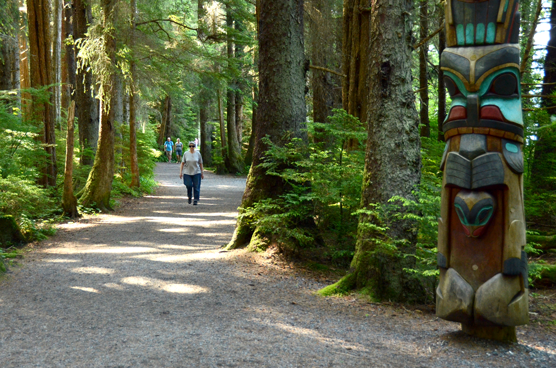
NPS Photo by Michael Hess
and mentally walking the trails at Sitka National Historical Park, one walker also became a little wealthier this month as a participant of the Park Prescription Program.
Betty Joe Whitcomb was the first recipient of the quarterly drawing of completed Park Prescription cards, earning her the $100 cash prize, and recognition at a brief ceremony at the park’s second annual National Trails Day earlier this month. 

As a longtime Sitka resident Betty Jo has walked the popular Totem Trail at the national park every day for several years, interacting with out-of-town visitors, meeting old friends, and enjoying the rich cultural history and natural beauty of the park. Even with the other 20 program participants, her odds of winning were good this quarter. 

She stops by the park visitor center each day after her walk, presenting her Park Prescription punch card to one of the rangers for verification of her activity. As much as she walks, Betty Joe expects to have at least another card completed before the next drawing in October. 

“[The prize] adds a little extra incentive,” said Ann Wilkinson, president of the Sitka Community Hospital Foundation, the local organization that funded the prize and also purchased waterproof cellphone cases for Park Prescription participants, which conveniently also fits a folded prescription card. 

“The more cards you fill up, the better your chances to win the money and, most importantly, the better you’ll feel,” she said. 

Betty Jo found out about the program in the local newspaper, but many other walkers learn about the program from their doctors – as a real prescription for real ailments. Sharing thoughts about the Park Prescription’s fountainhead initiative, Call to Action #6: “Go Take a Hike, and Call Me in the Morning,” National Parks Service director Jonathan B. Jarvis said, “Being outdoors has positive effects on health that don’t cost a dime” – a feeling shared by the participating local doctors. 

As a preventative measure, walking reduces the risks of obesity, diabetes, heart disease, improves mental health and provides many other health benefits. Eric Jordan, another regular Sitka walker and the first person to fill his Park Prescription logged 180 miles in his first 5 weeks, and later received a clean bill of health from his doctor. In other cases, cardiac patients recover with regular walks on the park’s improved trails, and mental health providers write scripts for exercise and sunshine. 

The freedom for participants to achieve their health goals at their own pace, creating their own personal exercise regime is among the stated strengths of the program, along with low startup costs. 

This focus on personal responsibility was also what attracted the attention of Sitka Health Summit board members when they granted support for the program last year, said Patrick Williams, health educator at the Sitka Community Hospital and a member of the Summit. The Summit meets every year to grant seed money to low-cost, high-gain community wellness opportunities. 

This year the Summit invested another $250 that will go towards printing another batch of Park Prescription cards that will be available to local healthcare providers. 

Though a fledgling program with ambitious goals, already people like Betty Joe Whitman, Eric Johnson, and the other diligent walkers, strollers, and runners are punching their Park Prescription cards for health, and maybe even a little wealth, on the trails of Sitka National Historical Park. 

For more information about the Park Prescription program as a healthcare provider, participant, or volunteer, contact Carin Farley, Sitka National Historical Park chief ranger and program coordinator, at (907) 747-0110.