Monday, July 1, 2013

Prescribing The Path to Wealth and Fitness

Story and photos by Michael Hess, Park Ranger, Sitka National Historical Park, Alaska
Sitka National Historical Park -- While many visitors are enriched physically
NPS Photo by Michael Hess
and mentally walking the trails at Sitka National Historical Park, one walker also became a little wealthier this month as a participant of the Park Prescription Program.
Betty Joe Whitcomb was the first recipient of the quarterly drawing of completed Park Prescription cards, earning her the $100 cash prize, and recognition at a brief ceremony at the park’s second annual National Trails Day earlier this month. 

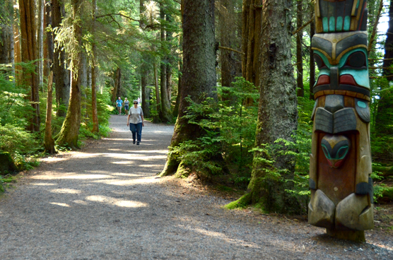
As a longtime Sitka resident Betty Jo has walked the popular Totem Trail at the national park every day for several years, interacting with out-of-town visitors, meeting old friends, and enjoying the rich cultural history and natural beauty of the park. Even with the other 20 program participants, her odds of winning were good this quarter. 

She stops by the park visitor center each day after her walk, presenting her Park Prescription punch card to one of the rangers for verification of her activity. As much as she walks, Betty Joe expects to have at least another card completed before the next drawing in October. 

“[The prize] adds a little extra incentive,” said Ann Wilkinson, president of the Sitka Community Hospital Foundation, the local organization that funded the prize and also purchased waterproof cellphone cases for Park Prescription participants, which conveniently also fits a folded prescription card. 

“The more cards you fill up, the better your chances to win the money and, most importantly, the better you’ll feel,” she said. 

Betty Jo found out about the program in the local newspaper, but many other walkers learn about the program from their doctors – as a real prescription for real ailments. Sharing thoughts about the Park Prescription’s fountainhead initiative, Call to Action #6: “Go Take a Hike, and Call Me in the Morning,” National Parks Service director Jonathan B. Jarvis said, “Being outdoors has positive effects on health that don’t cost a dime” – a feeling shared by the participating local doctors. 

As a preventative measure, walking reduces the risks of obesity, diabetes, heart disease, improves mental health and provides many other health benefits. Eric Jordan, another regular Sitka walker and the first person to fill his Park Prescription logged 180 miles in his first 5 weeks, and later received a clean bill of health from his doctor. In other cases, cardiac patients recover with regular walks on the park’s improved trails, and mental health providers write scripts for exercise and sunshine. 

The freedom for participants to achieve their health goals at their own pace, creating their own personal exercise regime is among the stated strengths of the program, along with low startup costs. 

This focus on personal responsibility was also what attracted the attention of Sitka Health Summit board members when they granted support for the program last year, said Patrick Williams, health educator at the Sitka Community Hospital and a member of the Summit. The Summit meets every year to grant seed money to low-cost, high-gain community wellness opportunities. 

This year the Summit invested another $250 that will go towards printing another batch of Park Prescription cards that will be available to local healthcare providers. 

Though a fledgling program with ambitious goals, already people like Betty Joe Whitman, Eric Johnson, and the other diligent walkers, strollers, and runners are punching their Park Prescription cards for health, and maybe even a little wealth, on the trails of Sitka National Historical Park. 

For more information about the Park Prescription program as a healthcare provider, participant, or volunteer, contact Carin Farley, Sitka National Historical Park chief ranger and program coordinator, at (907) 747-0110.

Sunday, June 30, 2013

Heavy Rain Slows Chisana River Fire


June 29, 2013
Beaver Creek, Yukon –– Heavy rain has dampened growth and activity on the Chisana River Fire in Alaska’s Eastern Interior. As a result, the international team managing the fire from Beaver Creek, Yukon, Canada is disbanding after a productive, cooperative effort. The Alaska Division of Forestry will continue to monitor the fire.

The fire was started by lightning May 31and is burning in Wrangell-St. Elias National Park and in the Tetlin National Wildlife Refuge. It is estimated at approximately 45,950 acres. The slight decrease in acreage from the previous estimate is due to better mapping of the fire.

No resources are threatened by the fire, but fire managers have developed contingency plans and are prepared to take action if that changes. The fire is approximately 13 miles west of the Canadian border, 17.5 miles west of Beaver Creek, Yukon, Canada and 21 miles northeast of Chisana.

Saturday, June 22, 2013

Rain takes toll on Wrangell-St. Elias's Chisana Blaze

Rain has helped to slow the growth of the Chisana River Fire and moderated the
spread of smoke. The fire, which was started by lightning on May 21, has grown to 29,910 acres.The fire made small movements to the east in parts of Wrangell-St. Elias National Park and the Tetlin National Wildlife Refuge.It remains approximately 13 miles from the Alaska Highway and 18 miles west of Beaver Creek, Yukon, Canada.

The State of Alaska Division of Forestry is monitoring the fire closely and consulting with the fire management officers from the U.S. Fish and Wildlife Service, National Park Service, and Yukon Territory in Canada. Despite the rain, vegetation in the area remains dry and conditions can change rapidly. Fire managers will take action if structures or natural or cultural resources are threatened, based on statewide firefighting priorities and resources available. None are threatened at this time.

The fire has created a smoky haze over the Alaska Highway, however visibility remains good.If smoke impacts the highway, motorists are asked to use caution by slowing down and driving with their headlights on.Updated information on travel conditions can be found at http://511.alaska.gov.

Wildland fire smoke information is available at http://www.dec.state.ak.us/air/smokemain.htm.

A Fuels and Fire Behavior Advisory remains in effect for most of Alaska, due to record heat and dry fuels.Read more at: http://fire.ak.blm.gov/content/weather/outlooks/FFBehavior.pdf.

Information will be updated when significant changes in fire activity occur. . Information about fires burning on National Park Service lands throughout Alaska is provided at http://www.nps.gov/wrst/parkmgmt/currentfireinfo.htm

Friday, June 21, 2013

Chisana River Fire Growth Slows

Copper Center, Alaska –– The Chisana River Fire activity slowed on June 19 moving in a southerly direction on the east side of the River with isolated and group torching.The fire grew from 25,566 to 29,287 acres. Wednesday's actions
included precautionary site protection for two cabins-- sprinklers and removal of flammable vegetation -- and the fire was mapped to determine the perimeter.

The fire is located 82 miles east of Slana, 21 miles northeast of Chisana, 19 miles west of Beaver Creek, Canada and approximately 14 miles southwest of the Alaska Highway border crossing. The State of Alaska Division of Forestry is monitoring the fire closely to document fire behavior and growth, while consulting with the fire management officers from the U.S. Fish and Wildlife Service, National Park Service, and Yukon Territory in Canada. Fire managers will take action if structures or natural or cultural resources are threatened. None are threatened at this time. The fire will be flown again at 5:00 p.m. today.

Information will be updated when significant changes in fire activity occur. Information and photos are also available at http://inciweb.org/incident/3440/.

Smoke will be visible and even heavy at times, in both Alaska and Canada. In Alaska, smoke will be likely visible throughout the Copper River Basin, from the Alaska-Canada border crossing, and along portions of the Alaska Highway. Wildland fire smoke information is available at http://www.dec.state.ak.us/air/smokemain.htm. If smoke becomes an impact to the highway, motorists are asked to use caution by slowing down and driving with their headlights on.

Several fires are burning statewide. For interagency wildland fire information, visit http://fire.ak.blm.gov or call 907-356-5511. Information about fires burning on National Park Service lands throughout Alaska is provided at http://www.nps.gov/wrst/parkmgmt/currentfireinfo.htm. For additional information, please contact Mark Keogh at 907-822-7223.

Thursday, June 20, 2013

Chisana River Fire Grows, Impacts the Copper River Valley

Smoke from the Chisana River Fire impacted the Copper River basin on the evening of July 18. Because the fire continues to grow anticipate varying levels of
smoke impacting the area.

The Chisana River fire grew from 7,718 acres on June 17 to 25,566 acres on June 18. The fire continued its growth to the south and west with some growth east - isolated tree torching and short range spotting was observed. Interagency fire staff provided protection to a structure that is southwest of the fire. The fire will continue to be monitored with planned flights today around 5:00pm.

The fire is located 82 miles east of Slana, 21 miles northeast of Chisana, 19 miles west of Beaver Creek, Canada and approximately 14 miles southwest of the Alaska Highway border crossing. The State of Alaska Division of Forestry is monitoring the fire closely to document fire behavior and growth, while consulting with the fire management officers from the U.S. Fish and Wildlife Service, National Park Service, and Yukon Territory in Canada.

Smoke will be visible and even heavy at times, in both Alaska and Canada. In Alaska, smoke will be likely visible throughout the Copper River Basin, from the Alaska-Canada border crossing, and along portions of the Alaska Highway. Wildland fire smoke information is available at http://www.dec.state.ak.us/air/smokemain.htm. If smoke becomes an impact to the highway, motorists are asked to use caution by slowing down and driving with their headlights on.

The fire is in a Limited suppression management option, per the Alaska Interagency Wildland Fire Management Plan. Wildfire is a natural process in the boreal forest. The fire is burning on U.S. Fish and Wildlife and National Park Service lands and agency personnel are allowing the wildfire to take its natural course.It is nature's way of renewing and revitalizing the landscape. Naturally-caused wildfires have on occasion burned in the northeastern portion of Wrangell-St. Elias and Tetlin National Wildlife Refuge. Interagency fire managers will take action if structures, natural or cultural resources are threatened. None are threatened at this time. Visit http://www.nps.gov/wrst/parkmgmt/loader.cfm?csModule=security/getfile&pageID=385664 to see a map of the area's wildfire history.

Several fires are burning statewide. For interagency wildland fire information, visit http://fire.ak.blm.gov or call 907-356-5511. Information about fires burning on National Park Service lands throughout Alaska is provided athttp://www.nps.gov/wrst/parkmgmt/currentfireinfo.htm. For additional information, please contact Mark Keogh at 907-822-7223.

Denali Moose Shooting Update: No Prosecution of Shooter Planned

Moose
Moose (Photo credit: Travis S.)
On Thursday, June 6 at approximately 7:30 pm the National Park Service received a report that a visitor had shot and injured a cow moose near the Denali Visitor Center. The visitor, Robert Sirvid, age 26, of Eagle River, Alaska stated that he and four other people, including two small children, encountered the moose at close range when they rounded a corner of the trail. They attempted to hide behind a tree, but the moose continued to charge. As she approached, Sirvid shot her at close range in the head. He stated afterwards that he did it because he was concerned for the safety of the children and felt he had no other recourse. He was visibly upset when he reported the incident to the responding rangers, who had to destroy the mortally injured moose.

After investigation of the statements of the party and a review of applicable law, the National Park Service has determined that no prosecution will be recommended to the Office of the United States Attorney.

The discharge of the firearm in the park is a violation of both 36 CFR 2.3(a)(1)(iii) and 2.2(a)(1) – using a weapon and taking of wildlife. Sirvid stated that he shot the moose to defend the lives of the children, and nothing found in the investigation contradicted that statement. While there is not a “defense of life” provision in the federal laws governing national parks, under Alaska State law this incident would be deemed a justifiable defense of life and not be charged as an offense. National Park Service wildlife biologists are actively following up on leads regarding two apparently orphaned moose calves that have been seen regularly in the area since the shooting. If the calves are located, the National Park Service will work with the Alaska Moose Federation to capture them and transfer them to a wildlife rehabilitation facility.

Wednesday, June 19, 2013

Amazing Images of Alaska Wildfire

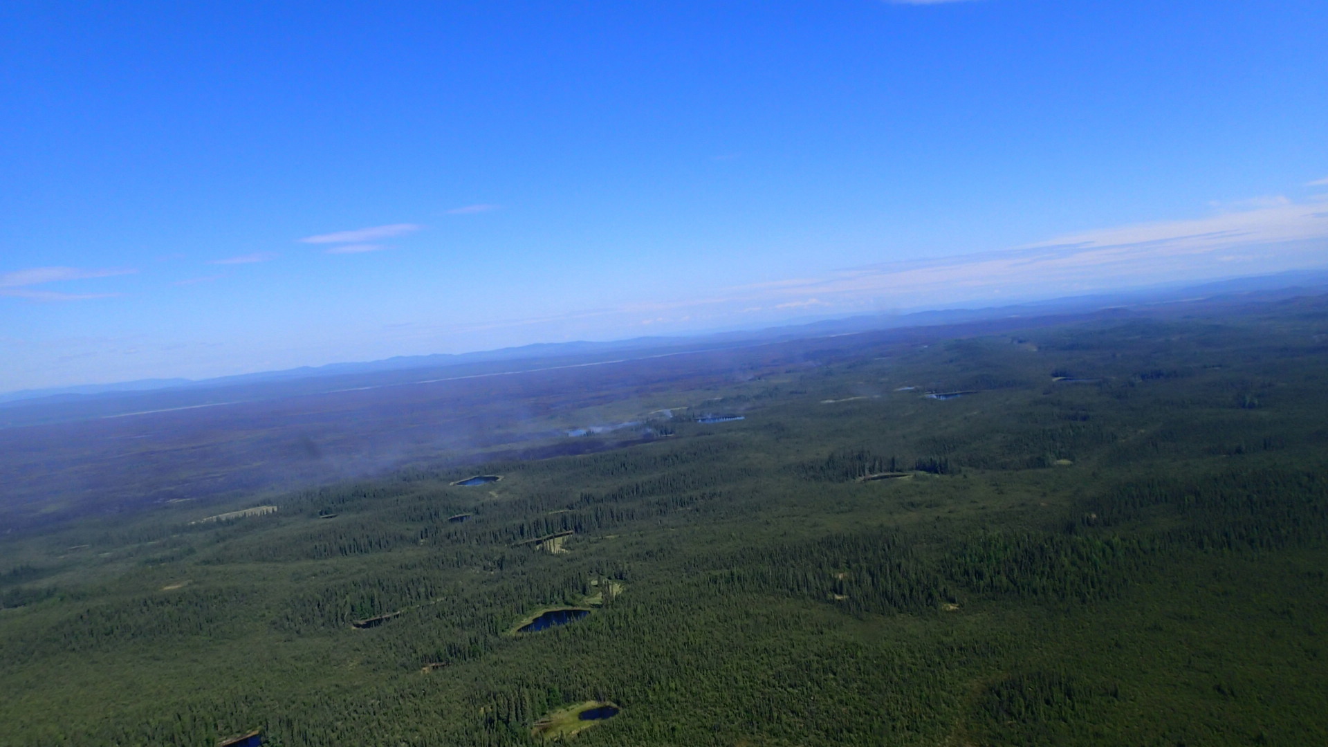
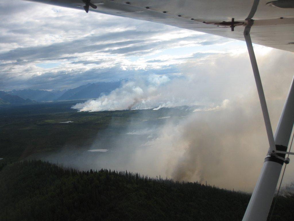
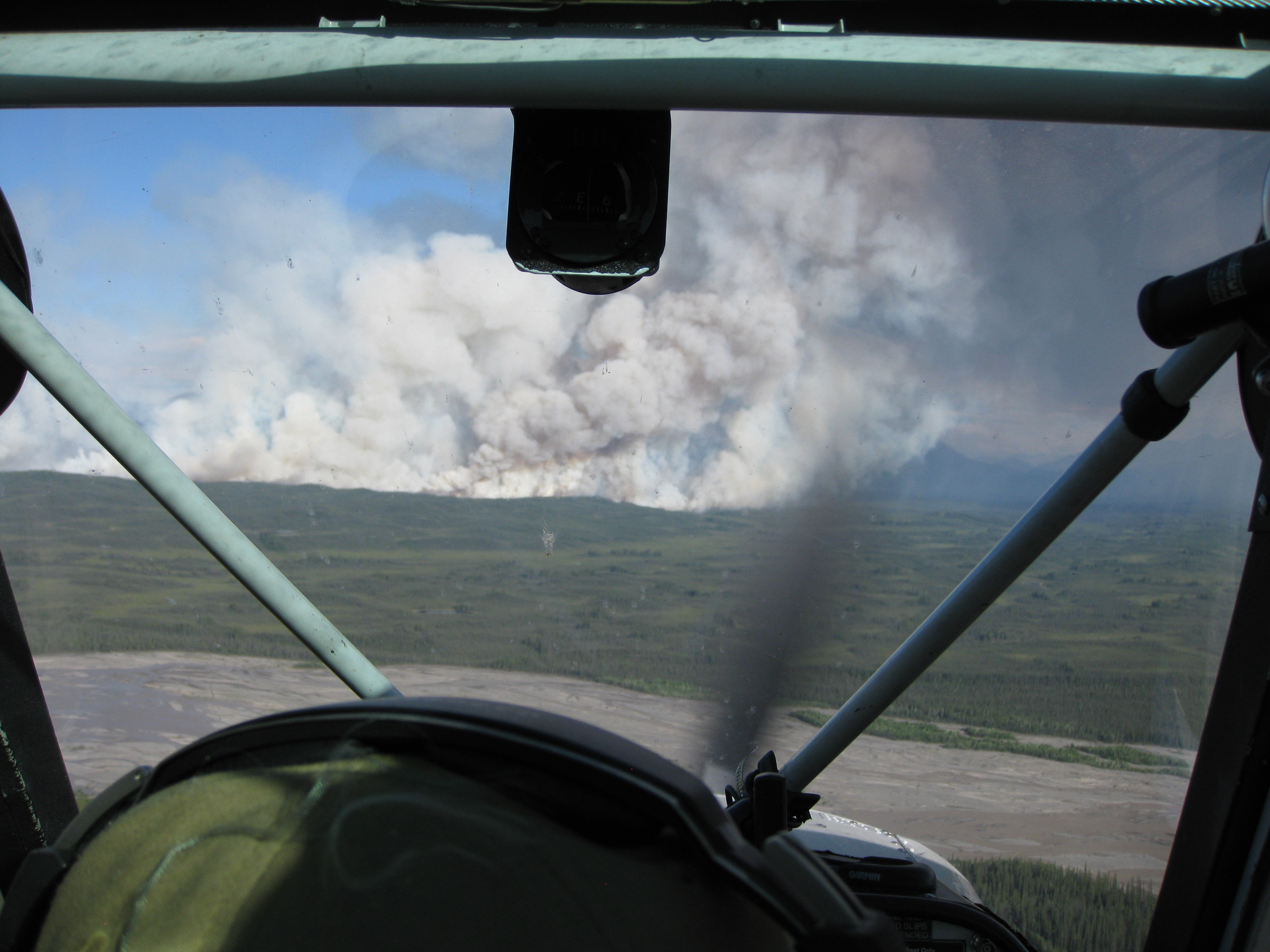
Due to continued hot and dry conditions, the Chisana River Fire grew from 2,900 acres to 7,718 acres June 17. The wildfire moved south from Tetlin Wildlife Refuge into northeastern Wrangell-St. Elias NP. As of June 17, the wildfire had
burned 3,847 acres in Tetlin Wildlife Refuge and 3,871 acres in Wrangell-St. Elias NP. The increased fire activity resulted in a 10,000 foot column of smoke that was visible from the Alaska Highway in Yukon Territory, Gulkana and McCarthy. Smoke from the fire can likely be seen and smelled in the Copper River Basin. Today, forecast extreme fire conditions will likely contribute to continued large fire growth and a large and visible column of smoke.

The Chisana River Fire is located 82 miles east of Slana, 37 miles northeast of Chisana, 19 miles southwest of Beaver Creek, Canada and approximately 14 miles southwest of the Alaska Highway border crossing. The U.S. Fish and Wildlife Service, Wrangell-St. Elias NP and State of Alaska Division of Forestry fire staff will continue to monitor the fire closely, documenting fire behavior and growth. Interagency fire managers will take action if structures, natural or cultural resources are threatened. None are threatened at this time. Fire managers are also communicating with Yukon Territory officials on a daily basis.

Staff are allowing the wildfire to take its natural course. Wildfire is a natural process in the boreal forest. It is nature's way of renewing and revitalizing the landscape. Naturally-caused wildfires have on occasion burned in the northeastern portion of Wrangell-St. Elias and Tetlin National Wildlife Refuge. Visit http://www.nps.gov/wrst/parkmgmt/loader.cfm?csModule=security/getfile&pageID=385664 to see a map of the area's wildfire history.

Visit http://www.nps.gov/wrst/parkmgmt/currentfireinfo.htm for current fire information.