Friday, May 17, 2013

All Areas of Denali National Park and Preserve 1980 Additons Closed to Snowmobile Use; Cantwell Area Trails Temporarily Closed to ORV Use

Grizzly bear in Denali National Park
Grizzly bear in Denali National Park (Photo credit: Wikipedia)

DENALI PARK, Alaska:Denali National Park and Preserve Superintendent Don Striker has determined that due to the deterioration of the snowpack, there is no longer adequate snow cover for the use of snowmobiles for traditional activities in the 1980 additions to Denali National Park and Preserve on both sides of the Alaska Range. All park lands that were open for snowmobile use are now closed for the season. Even in areas such as Broad Pass and near Cantwell, the warmer temperatures and long days have reduced snow depths to a level that is no longer adequate to protect vegetation and soils from damage by snowmachine use.
All lands within the former Mount McKinley National Park on both the north and the south sides of the crest of the Alaska Range are closed to all snowmobile use throughout the winter by federal regulation.
Effective immediately, the Windy Creek Trail, Cantwell Airstrip Trail, Pyramid Trail, Cantwell Creek Floodplain Trail/Corridor, and the Bull River Floodplain Trail/Route are temporarily closed by regulation (36CFR 13.903 and 13.460) to the use of off-road vehicles (ORVs) by authorized subsistence users in order to protect vegetation and soils from damage. The temporary closure will allow the trails to dry in order to sustain ORV traffic. These trails could re-open for use on June 15, 2013, but this year's opening could be later due to the unusually wet and cold spring. A map of the trails is posted on the park website atwww.nps.gov/dena/parknews/upload/ORV%20Closure.jpg.
Additional park information is available on the web at www.nps.gov/dena or by calling 907-683-9532 from 9:00 am - 4:00 pm daily.Stay connected with "DenaliNPS" on Twitter, Facebook, YouTube, Flickr, and iTunes - links to these social media sites are available at www.nps.gov/dena/connect.htm.

Wednesday, May 15, 2013

ADF&G PROVIDES NEW TOOL FOR ANGLERS


The Alaska Department of Fish and Game (ADF&G), Division of Sport Fish recently developed a new Google Earth mapping application that is now posted on the department’s website and available for public use. The application provides anglers and other information seekers with easy access to contour
maps, photographs, fish data, stocking records, and historic documents for over 1,300 water bodies throughout the state.

ADF&G is confident the user-friendly Alaska Lake Database (ALDAT) application has something for everyone. Water bodies are marked on a Google Earth map with colored pins, making stocked fisheries identifiable at a glance. Anglers can search potential fishing locations by name, area, stocking date, or fish species. Outdoor enthusiasts can manually navigate the map using their mouse and overlay useful layers such as roads and trails. Students, managers, and researchers can export lake data across multiple datasets and specify the fields they wish to include in their request using the data export page.

“Alaska’s lakes are teeming with fish, and each provides exciting opportunities for sustainable sport fishing opportunities. This innovative approach to providing information in a manner that is easily accessible and tailored to the needs of our Alaskan anglers is consistent with the division’s goal to inform the public about recreational fishing opportunities with an emphasis on exceptional customer service,” said Charlie Swanton, Director of the ADF&G Division of Sport Fish.

Check it out today! Get started planning your next fishing trip by visiting: www.adfg.alaska.gov/index.cfm?adfg=fishingSportStockingHatcheries.lakesdatabase or go to: www.adfg.alaska.gov and click on “Fishing” and then “Sport”. On the left hand side of the page, click on “Alaska Lake Database.”

Tuesday, May 14, 2013

Vessel Operating Restrictions Implemented To Protect Whales


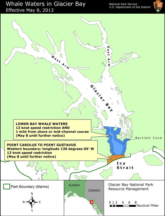
Glacier Bay National Park and Preserve Superintendent Susan Boudreau announced today that a vessel speed limit of 13 knots through the water will be implemented in lower Glacier Bay and in Park waters at the mouth of Glacier Bay to protect numerous humpback whales that have been sighted in this area. During the past week, 17 different humpback whales have been observed feeding in this area. This speed restriction will apply to all vessels from 5 AM Wednesday May 8 until further notice. In addition, in lower Glacier Bay whale waters, vessels greater than 18 feet in length are restricted to a mid-channel course or 1 nautical mile offshore. 
As shown on the attached map, the designated lower Glacier Bay whale waters include the waters extending from the mouth of Glacier Bay to a line drawn between the northern tip of Strawberry Island and the northern tip of Lars Island. This boundary is shown on NOAA nautical charts of Glacier Bay.   
The whale waters at the mouth of Glacier Bay are bounded on the north by an imaginary line between Point Carolus and Point Gustavus, and on the south by the Park boundary in Icy Strait. The eastern boundary is an imaginary line running due south from Point Gustavus to the Park boundary, and the western boundary is an imaginary line running due south to the Park boundary following longitude 136 degrees 05' West.  
Boaters are reminded that vessels are prohibited from operating within ¼ nautical mile of a humpback whale in Park waters, including those Park waters outside Glacier Bay proper.  In addition, vessel operators positioned within ½ nautical mile of a humpback whale are prohibited from altering their course or speed in a manner that results in decreasing the distance between the whale and the vessel.  Speed and course restrictions in whale waters are intended to reduce the disruption of feeding humpback whales and to lower the risk of whale/vessel collisions.  Boaters should proceed cautiously in all areas where whales are present because whales may surface in unexpected locations, posing a hazard to both the vessel and the whale. Although humpback whales tend to be distributed along the shoreline, boaters should note that whales frequently cross mid-channel as they move between feeding sites. 
Boaters are advised to verify whale waters designations prior to entering Glacier Bay by telephoning (907) 697-2627 or by contacting KWM20 Bartlett Cove on marine VHF radio.  

Sunday, May 12, 2013

National Forest Surveys Coming Your Way!!!

English:


Soon, you may see Forest Service employees working in developed and dispersed recreation sites and along Forest Service roads wearing bright orange vests and hanging out near a “Traffic Survey Ahead” sign. Just like the postman these folks may be out in all kinds of weather conditions and they want to talk to you. These well trained interviewers want to know about your visit to the national forest.  
This on-going national forest survey has already been conducted once on every National Forest in the country.  We are now returning 5 years later to update the information, as well as to look at recreation trends over time. The information is useful for forest planning and local community tourism planning. The more we know about visitors, especially their satisfaction and desires, the better managers can provide for those needs. The surveys provide National Forest managers with an estimate of how many people actually recreate on federal lands and what activities they engage in while there.  Other important information forest and tourism planners need includes, how satisfied people are with their visits and the economic impact of your recreation visit on the local economy. Many small towns are struggling and hope that tourism may help strengthen their communities.  The information gathered in the surveys is one way to estimate the effects.
This recreation visitor program gathers basic visitor information.  The interviews last about 8 – 15 minutes. The questions visitors are asked include: where you recreated on the Forest, how many people are you traveling with, how long have you been on the Forest, what other recreation sites you visited while on the Forest, and how satisfied were you with the facilities and services provided. About a third of the visitors will be asked to complete a confidential survey on recreation spending during their trip.
It’s important for survey takers to talk with local people using the forest as well as out-of-area visitors. We want all types of visitors represented in the study, so if you see us out there please stop for an interview.  All information you provide is confidential and the survey is voluntary. If you have any questions about this program you can visit our web site athttp://www.fs.fed.us/recreation/programs/nvumor contact Hope Roenfanz at 907-288-7709.


Saturday, May 11, 2013

Visitor Facilities and Services at Denali National Park Opening for Summer Season

English: Willow ptarmigan chicks in Denali Nat...


DENALI PARK, Alaska: Lengthening days, milder overnight temperatures, sightings of migrant bird species, and the arrival of summer employees are all signs that the seasonal facilities and services that enhance the park experience for Denali National Park and Preserve visitors will open soon.
The Denali Bookstore, operated by park partner Alaska Geographic, has kicked off the season, as it opened on Monday, May 6. Most facilities will open the following week on Wednesday, May 15, including the Wilderness Access Center, Morino Grill, Backcountry Information Center, and the Denali Visitor Center, the park's main visitor center. This environmentally sustainable facility features stunning exhibits on Denali's natural history and cultural heritage, screenings of the award winning, high definition feature film, "Heartbeats of Denali", and friendly rangers who answer questions and help visitors plan how to spend their time in the park. It is open daily from 8:00 am - 6:00 pm.
The season's first interpretive offering, the daily 2:00 pm sled dog demonstration, commences on May 15. Free buses to the park kennels depart from the Denali Visitor Center shuttle stop at 1:20 p.m. Campground programs will be offered on a limited basis beginning Saturday, May 18, and the 10:00 am sled dog demonstration begins on Monday, May 20. The full range of interpretive programs will be available in June.
Denali Natural History Tours start on Tuesday, May 14, and the shoulder season Tundra Wilderness Tour (TWT) to the Teklanika Rest Area will be available May 14 - 19. The regular TWT begins on May 20.
The park road is open for travel by private vehicles to the Teklanika River Rest Area (Mile 30) through Sunday, May 19. Weather and road conditions permitting, on Monday, May 20 the park's shuttle bus system starts providing visitor access beyond the Savage River (Mile 15) as far west as the Toklat River (Mile 53). Buses will begin running to the Eielson Visitor Center (Mile 66) on Saturday, June 1. The entire 92-mile length of the park road will open for buses on Saturday, June 8.
The first fifteen miles of the park road will remain open for travel by private vehicles throughout the summer season. This year's road-related construction projects, which include the replacement of the Rock Creek Bridge near park headquarters, are expected to cause only minor (up to five minutes) traffic delays and lane closures.
Camping is free at the Riley Creek Campground until fee collection begins on May 15. Water and sewer services may be available by that date, depending on weather conditions. The Savage River Campground will open on Sunday, May 19 and the Sanctuary River, Teklanika River, and Igloo Creek Campgrounds all open on Monday, May 20. The Wonder Lake Campground opens on Saturday, June 8.
Denali National Park and Preserve collects an entrance fee year-round. The entrance fee of $10 per person (for visitors age 16 and older) is good for seven days. Visitors can pay the entrance fee at the Murie Science and Learning Center (MSLC) through May 14, and at the Denali Visitor Center (DVC) beginning May 15. The majority of the money collected remains in the park to be used for projects to improve visitor services and facilities. Interagency Federal Recreation Passes such as the Annual, Senior, and Access Pass, and the Denali Annual Pass are also valid for entry into the park and can be purchased at the MSLC or DVC.

Friday, May 10, 2013

Application Period for Denali National Park 2014 Artists-in-Residence Program Open

Denali National Park


DENALI PARK, Alaska: Denali National Park and Preserve is seeking applications from visual artists and writers for the 2014 Artist-in-Residence Program. This program provides the opportunity for established artists and writers to use an historic roadside cabin as a base to explore the park and seek inspiration from it. Many of the works created by previous artists-in-residence are displayed in the Denali Visitor Center and the Eielson Visitor Center. "These interpretations of the park's landscape, wildlife, and cultural history provide a superlative means to connect our visitors to the beauty and complexity of this great national treasure," said Superintendent Don Striker.
Selected artists reside in the East Fork cabin, located at Mile 43 on the park road, for a ten day period between June and mid-September. In return for their residency, each artist donates a piece of artwork or written piece inspired by their time in the park to the park's collection. Artists also offer a public presentation for visitors at the end of their residency.
A link to the online application and more information about the program is available athttp://www.nps.gov/dena/historyculture/arts-program.htm.Applications for the 2014 season must be submitted by September 30, 2013.Notification letters will be sent out by December 15, 2013.
The Artist-in-Residence program is a national program. Artists have played a significant role in raising public awareness of the natural wonders preserved within the National Park System and the need for their protection since the creation of Yellowstone, the first national park. This is the 13th year of Denali's program.

Thursday, May 9, 2013

Denali Park Road Open to Mile 30

The single road within Denali National Park


Extra effort by the spring road opening crew and other maintenance employees to clear the snow from recent storms has made it possible for the National Park Service to provide access farther west into the park. Park visitors can now drive as far as the Teklanika River Rest Area at Mile 30.
Snow conditions are still good for cross-country skiing, snowshoeing, and other winter recreational activities, but with warming temperatures conditions will change rapidly. The spring road opening crew has reported sightings of moose, caribou, coyote, lynx, golden eagles, ptarmigan, and a single arctic ground squirrel. There have been no sightings of bears yet this season.
Vault toilets are available for visitor use at the Teklanika Rest Area, parking areas on both sides of the Savage River and the Mountain Vista Trailhead (rest area) east of the Savage River Campground. Other park facilities west of headquarters, including the campgrounds, remain closed until later in May.
Visitors should expect to encounter snow, ice, and mud on some portions of the road, particularly in shaded sections. Motorists are also advised to be alert for National Park Service personnel steaming culverts along the side of the road, and for heavy equipment being used in the road opening operations.
Weather conditions can change rapidly at this time of the year, and the road may open and close several times. Visitors are encouraged to contact the park for updated road and weather information. For those interested in following the progress of the Denali road crew as they plow westward along the 92 mile park road to Kantishna, timely updates are posted on the park website at http://www.nps.gov/dena/spring-road-opening.htm. Photos are posted on the park's Facebook page at www.facebook.com/DenaliNPS.
The Riley Creek Campground at Mile 0.2 is open, and camping is free until May 15. A vault toilet is provided in the loop that remains open year-round, and campers can obtain water at the Murie Science and Learning Center. Water and sewer services will not be available until mid to late May.
The Murie Science and Learning Center (MSLC) at Mile 1.3 is open daily from 9:00 am to 4:00 pm for visitor information and backcountry permits.
Denali National Park and Preserve collects an entrance fee year-round. The entrance fee of $10 per person (for visitors age 16 and older) is good for seven days. You can pay the entrance fee at the MSLC. The majority of the money collected remains in the park to be used for projects to improve visitor services and facilities. Interagency Federal Recreation Passes such as the Annual, Senior, and Access Pass, and the Denali Annual Pass are also valid for entry into the park and can be purchased at the MSLC.
Additional park information is available on the web at www.nps.gov/dena or by calling (907) 683-9532 from 9:00 am to 4:00 pm daily. Stay connected with "DenaliNPS" on Twitter, Facebook, YouTube, Flickr, and iTunes - links to these social media sites are available at www.nps.gov/dena.