The Alaska Department of Transportation & Public Facilities (ADOT&PF) has indefinitely closed the Copper River Highway at mile 36 due to safety concerns at Bridge No. 339. The closure will last until the bridge is replaced.
The 56-mile Copper River Highway is located near Cordova and ends at the Million Dollar Bridge. The road, frequented by hunters and recreationists, leads to vast areas of proposed resource development.
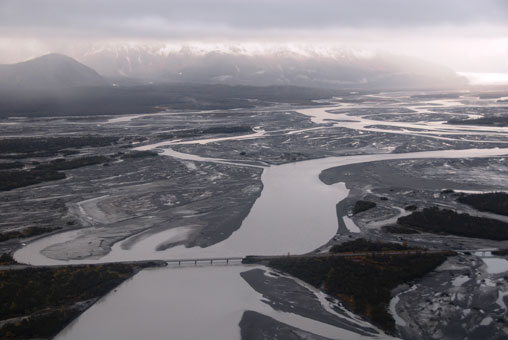
Bridge No. 339 is one of eleven bridges crossing the Copper River Delta. Naturally occurring changes to the flow of water between channels across the delta led to a dramatic increase in the amount of water running under the bridge. Due to the increased amount of water, 50 ft of “scour”, or erosion, was observed at the bridge in 2011. The scour resulted in a lowering of the channel bottom that compromised the structure of the bridge and necessitated the closure.
Bridge No. 339 was constructed in 1977. Based upon the channel configurations at that time, bridge designers estimated that water under the bridge would flow at 18,500 cubic feet per second (cfs). During the summer of 2011, U.S. Geological Survey (USGS) hydrologists measured the water flow to exceed 85,000 cfs.
Channel and flow distribution changes are a natural part of deltaic river systems. The adverse effects of these changes on Bridge No. 339 was first noted in 2009, when the bridge began receiving a greater portion of the total Copper River flow than its neighboring bridges. In 2010, ADOT&PF and the USGS began a comprehensive monitoring program at the bridge that included frequent on-site inspections and the use of bridge sensors that enabled remote observation of the bridge.
ADOT&PF received funding this fall to start the design phase of a replacement bridge; the design phase will progress through 2013 with agency permitting in 2014. Pending the availability of construction funds, the construction project could begin as early as 2015.